5 Mile
Like children, all mile roads are unique. But Five Mile (aka Fenkell) really is. It doesn’t exist on the east side. It starts out urban at M-10 and ends up bucolic by U.S. 23.
Fenkell shows that it’s tough right away. The first scene: “Satan’s Sidekicks” motorcycle club. There are hints of former prosperity; surviving wig shops and nail salons mingle with abandoned storefronts and vacant land. Like much of the city, religion helps hold things together, from established sites like Loyola High School to storefronts like New Liberty Apostolic. (It’s a toss-up whether there are more churches or party stores.) Blessed Ground International Ministries sits across from the shell of the legendary Watts Club Mozambique male strip joint (it burned in 2015).
Mixed among the fast food offerings: Akbar’s restaurant, plus a few joints that look like they may or may not be open. Model apothecary bottles line outside the drug-less Sam’s Liquor Shoppe and Pharmacy.
Further west is solidly residential (Grandmont and Rosedale Park). Cross Evergreen into beleaguered Brightmoor for more motorcycle clubs, urban gardeners, and churches.
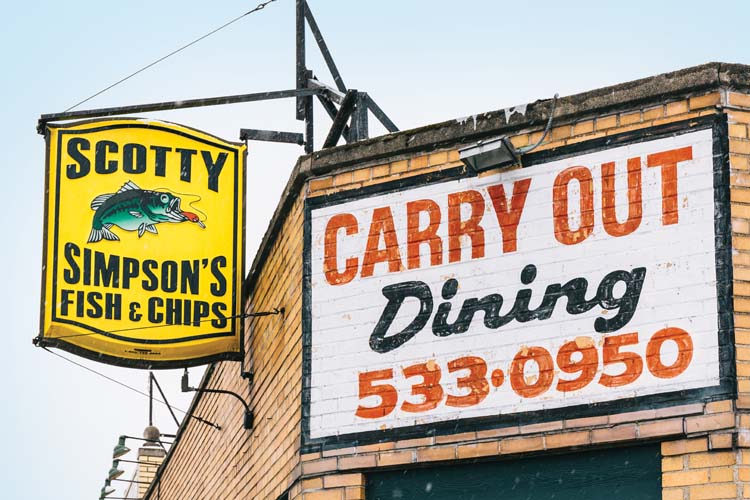
Another type of faithful gather at Scotty Simpson’s Fish & Chips, there since 1950.
Cross the Rouge River and you’re into the bedroom community of Redford Township. Some of those rooms look out on Lola Valley Park, where The Upper Rouge River winds through the neighborhood.
Redford has a host of small shops, such as Floyd’s Flowers Inc. and Ackroyd’s Scottish Bakery near Beech-Daly Road (try the shortbread or sausage rolls).
Roll past elements of our rural past, from Chap’s Feed Store to Ropertis Turkey Farm, and Tony’s Mower Shop and Trains.
After twists and turns around Phoenix Lake, spy the tower at The Inn at St. Johns. The biggest surprise? An abandoned prison in Plymouth. The former Detroit House of Correction was established in 1927. Continue west to Brae Burn Golf Club and U.S. 23.
Room at the Inn
Back in 1948, The Inn at St. John’s was St. John’s Provincial Seminary. As seminarians declined, the Archdiocese of Detroit closed it. In 1994, it was revived for retreats and conferences. Today, it’s St. John’s Golf & Conference Center, with three appropriately named nines (Matthew, Mark, and Luke), a hotel, and 5ive Restaurant.
44045 Five Mile Rd., Plymouth.
 All Aboard at Tony’s
For 30-plus years, area residents bought new and used lawn and snow equipment — and got old stuff service — at Tony’s Mower Shop and Trains. A dozen years ago, they added Lionel trains into the mix, plus hobby items.
40970 Five Mile Rd., Plymouth
6 Mile
From a shuttered 1800s schoolhouse to a nearly abandoned east-side neighborhood that’s going fallow, Six Mile (aka McNichols Road) is a study in contradictions.
In Wayne County’s far western reaches, Six Mile is dirt road. An abandoned school at Napier Road sits by Thayer Cemetery and Thayer’s Corner Nature Area. Heading east, Steeplechase of Northville has homes priced from just under $600,000 (you get paved roads, though).
Rural vestiges like George Farms give way to massive Northville High (2,200-plus students). In Livonia, Trinity House is surrounded by a cemetery, but it’s a community theater.
In Redford Township, the young at heart stop for Vicky’s Homemade Ice Cream. Six Mile becomes McNichols at the Detroit border (a side street called Five Points). There’s a new Meijer on the old Redford High site.
In North Rosedale Park, Just a Bit Eclectic has great tea and fabulous collectibles. Also nearby: the venerable Knudsen’s Danish Bakery.
New businesses are popping up east of Southfield. One of the best is The Pasta Bowl. The stretch also includes Mini Mart Specialty Meat (since 1975) and Piquette Market (50-plus years).
The neighborhood around Livernois Avenue isn’t called University District for nothing. Nearby, there’s Marygrove College, University of Detroit Mercy, and even a Barber College.
Approaching Woodward, gated houses sit on the southern border of the Detroit Golf Club. Before Woodward, you’re in Detroit’s original “gayborhood.” Legendary Bookie’s is gone, but Menjo’s is still thriving.
Cross Woodward to the east side, and there’s a noticeable industrial feel. Gritty early strip malls are interspersed with junkyards, residential areas, and storefront churches. There’s the original Buddy’s by Conant Street. Mound Road has more industrial stretches near railroad lines. Hit Van Dyke Avenue and you dead-end at the massive Mt. Olivet Cemetery (its 300-plus acres include Purple Gang founder Joseph Zerilli’s remains). You can almost see McNichols continue across the runway of Coleman A. Young International Airport. But it’s a major detour. Hint: Go up Van Dyke to Seven Mile and head east.
Once you rejoin McNichols, it gets more residential. Near Gratiot Avenue, there’s God’s Oasis Church of God and The Assumption of the Blessed Virgin Mary is a block north (started in 1830 by German immigrants. East of Gratiot, McNichols turns into Seymour Street. It’s “residential,” with some vacant areas. Hip to be Square
Although Buddy’s now has 10 or so locations, it all began here at Conant and Six Mile. Originally a neighborhood tavern in 1930, they’ve been serving up Detroit-style square pizza since 1946. 17125 Conant St., Detroit
Tea Time in the Park
North Rosedale Park’s Just a Bit Eclectic (open Thursday-Saturday) has a good selection of loose teas and related items, of course, plus proprietor Darlene Alston has marvelous collectibles she might part with (most are not for sale). 19015 W. McNichols Rd., Detroit
7 Mile

From sea to shining sea? Maybe not. But from Lake St. Clair to Whitmore Lake, Seven Mile (aka Moross Road) has everything from alabaster-like mansions to amber waves of farmland.
Pier Park marks the start of Moross at Lakeshore Drive in Grosse Pointe Farms. Just west are the fairways of the affluent Country Club of Detroit (members only).
It’s mostly residential until Harper Woods and I-94. A sign announces the Moross Greenway, a $500,000 effort to spruce up traffic “islands” between I-94 and St. John Hospital.
Moross becomes Seven Mile after Kelly Road. After Gratiot, there’s Osborn High School and the mysteriously named My Other Brother private club.
Other notable places: Jimmie Paul’s Hands On Boxing Gym and the massive Solomon’s Temple Church.
After passing the Arab American and Chaldean Council Youth Center, and Woodward, you’re officially on the west side.
There’s the nearly 300-acre Palmer Park. The Avenue of Fashion (aka Livernois) is buzzing lately, including Kuzzo’s Chicken and Waffles and rumors of a Bucharest Grill. Past Palmer Woods is the still-thriving U-D Jesuit High. It’s building a $16 million Science and Engineering Center.
A bit west is Tom’s Tavern, an iconic dive with uneven floors. More signs of retail life include a newer Home Depot. And there’s always a line at Motor City Soul Food.
Spot the abandoned Rogell Golf Course, which Greater Grace Temple bought from the city and unsuccessfully tried to flip as a cemetery.
Cross Telegraph, then Inkster Road into Livonia. Neighborhood hangout The Sands Grill and Bar looks more like it should be up north.
It turns largely residential, with outlets like George’s Livonia Gardens and the Livonia Italian Bakery and Café ($1.95 Italian bread on Sundays).
More substantial meals can be had at Gaucho Brazil Steakhouse or Rocky’s of Northville. Then look for the abandoned Northville Psychiatric Hospital.
Seven Mile dead ends at Northville Road, but picks up at Northville Downs. Seven Mile turns into Edward N. Hines Drive and briefly into Fairbrook Street. You’re not lost. You’re at 17-acre Fish Hatchery Park.
Things get rural (with occasional McMansions). Golf at Downing Farms Gulf Course or learn to ride English style at Wildwind Equestrian Center. Need a new or used saddle? Check out Backyard Tack in South Lyon. Seven Mile ends at East Shore Drive, which winds its way around Whitmore Lake.
Get In line! It’s Good for the Soul!
There’s always a wait for the hefty portions of cube steak or smothered pork chops at Motor City Soul Food. Plus there’s collard greens, catfish, oxtails, chitterlings, and oh, so much more. It’s carryout only, but the line moves quickly. (Hint: Get there early. The meatloaf and other items can sell out.)
12700 W. Seven Mile Rd., Detroit
8 Mile
The most interesting of mile roads? Excitement on every corner?
“No”… and “No.”
However, from dirt-road-dead-end near Oakland County’s border to the shores of Grosse Pointe Woods, Eight Mile (aka Baseline Road, aka M-102, aka Vernier Road) has a bit of everything.
Heading east, it’s pretty rural. There’s the Maybury Farm educational center for kids and the 940-plus acre Maybury State Park (horseback riding, fishing, bike trails, etc.).
Stop in The Barn in Northville for antique shopping. For more old-time fun, visit Mill Race Village on Old Baseline. There’s Parmenter’s Cider Mill, plus the Northville Winery and Brewing.
The “new” stretch has more history. It’s the 100th anniversary for Meadowbrook Country Club. There’s also Greenmead Historical Park. Modern activities include Riley Skate Park — Farmington Hills’ way to keep skateboarders off civic steps.
Shops range from Ritter’s Custard Shop to Cirilla’s adult store, a foreshadowing of what’s to come. Just before the Detroit border is the former Detroit Gator Shoes, now Royce’s.
Cross into Detroit and you hit strip clubs. Names like Ace of Spades and Silver Rain Gentlemen’s Club fight for attention with marijuana dispensaries, like the aptly dubbed StarBuds. There’s a tale of two Northlands: the longstanding Northland Roller Rink followed by the slated-for-the-wrecking-ball Northland Shopping Center in Southfield.
The road sports billboards, notably, TV pawn stars from American Jewelry and Loan.
There’s retail icons like Hagopian Rug and Hot Wheel City. Then some barbecue spots, Detroit Vintage Coffee Shop, and at Livernois, Baker’s Keyboard Lounge.
You’d think the crossroads Eight and Woodward would be cool? Not.
There’s a Meijer, a no-tell motel, and the old State Fair grounds.
Continue east to more weed shops, strip clubs, pawn shops, furniture stores, and a surprising number of vacant tracts, especially to the north.
There’s a fair amount of industrial, from Axle of Dearborn to the massive Chrysler Truck Plant.
There’s also lots of action. Cops pull someone over at a weed store. Homeless folks stake claims at populous corners, anti-abortion protesters gather at women’s clinics. Hooker alert: There’s a police warning for a decoy area before I-75.
Other notable sights: Holy Trinity Orthodox Church west of Ryan, and the Light Guard Armory (where you can still sign up to ship out, soldier!).
There’s Towne Club Bottling Co. near Mt. Elliott, Bhogalli Leather in Eastpointe, and the urban answer to Northville’s Barn: Fred’s Furniture and Antiques in Warren. Oh, and there’s Action Impact Firearms and Training.
Hit Harper Woods and mega-shopping at Eastland Center. Here, Eight Mile splits off into residential, leaving you on Vernier. There’s Rex’s Deli (old-timers may remember them as Lefkofsky’s). Try the Eight Mile specials (two eggs, meat or hash browns, and toast for $3.35).
Along Vernier, Harper Woods and Grosse Pointe turn largely residential after I-94. It ends where The Grosse Pointe Yacht Club meets the water.
Gator Skin in the Game
 What do you do when you’re booted from the place you’ve done business for 30 years? Reload. That’s what happened to Detroit Gator Shoes after Northland Mall closed. Now they’re in a place called Royce just before the Detroit border in Redford. They’ve got exotic boots (ostrich, alligator, crocodile, and yes, even elephant). Plus repairs, purses, belts, and more. They’re branching out to offer lighting and décor components, too. It’s right next door to a place called Michigan Industrial Shoe, where you can find some less exotic Carhartts.
25525 W. 8 Mile Rd., Detroit
The Wheel Deal

Replace your rims at Hot Wheel City. You can’t miss their two Eight Mile locations at night with their neon blues and reds. They started with one shop on Seven Mile in 1995 and since expanded to eight metro locations. 13540 E. 8 Mile Rd., and 14711 W. 8 Mile Rd., Detroit
Eight Miles From Where?
Why is it called Eight Mile? Contrary to some reports, it’s not 8 miles from somewhere on the riverfront. Nor is it measured from the base of Woodward and Jefferson avenues.
Part of the answer goes back to the Land Ordinance of 1785, a system devised in part by Thomas Jefferson so that settlers could purchase farmland in the undeveloped west.
Eight Mile is also known as Baseline Road. It’s a line that goes across the entire state of Michigan, set so that surveyors could divide townships and counties into neat and tidy square mile segments. The survey began in 1815.
A great many roads on the metro grid — both north/south and east/west — are a mile apart.
It is true, however, that Baseline Road is approximately 8 miles north of the junction of Woodward and Michigan avenues. That’s the so-called “point of origin” set by Augustus Woodward when a new Detroit arose from the ashes of a fire in 1805 (check out the marker in Campus Martius Park).
On to 9 – 12 Mile.
Part of our City Guide 2016, exploring metro Detroit mile by mile.
|
|
|